Product Overview
Micromine Origin
Prospect smarter, model faster and estimate with greater confidence.
Integrate, validate, interpret and communicate critical mineral resource data with state-of-the-art geological tools spanning from early exploration through to resource evaluation. Micromine Origin equips exploration geologists with comprehensive, flexible and powerful tools to target and assess prospective regions more efficiently. Plus, rapidly translate geological knowledge into complete models using streamlined tools that don’t sacrifice quality or control. Resource Geologists can carry out complex estimates with confidence using one of the most comprehensive resource modelling solutions on the market.
Specifications
Drillhole and surface data management:
Effortlessly plan, review, amend, report and extract insights from drillhole and surface data.
Import, validate, process, visualise, plan and interpret a wide variety of surface, drillhole and subsurface data in 3D.
Combine, simplify, or redistribute drillhole data using downhole, grade, interval, geology (and other) compositing methods.
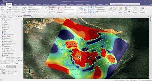
3D GIS capability
A powerful 3D GIS visualisation environment for optimised interrogation and comprehension of spatial data.
Visualisation of 2D, 3D and downhole geophysics data
Rapidly import, validate and interpret a wide range of geophysical data including LAS, 2D and 3D SEG-Y, in a representative 2D and 3D environment. Create effective plans and cross-sections using advanced spatial editing and intuitive wireframe functionality.
Implicit modelling
Fast track your understanding of any structural or grade boundaries with industry-leading, fast, reliable and comprehensive implicit modelling capability. Model grade shells, lithological boundaries, faults and surfaces using Micromine’s 3D modelling algorithm and the industry-standard radial basis function (RBF).
Interactive and flexible 3D modelling
Define geological features your way with tools to build, manage and manipulate 3D solids and surfaces for exploration, resource estimation and geological modelling. Enjoy powerful and intuitive tools that keep you in control for visually constructing 3D models such as geological interpretations using points, profile shapes or polygons.
Plotting, charting and reporting tools
All the functionality needed to efficiently plan, visualise, evaluate, estimate and report surface and drillhole data. Create press-style plots with ease in our dynamic plotting environment featuring dynamic scaling and panning as well as a variety of high-resolution export options.
Geostatistical analysis
Analyse, model, estimate and assess uncertainties in spatial data across your deposits. Generate optimal parameters from sample data and evaluate predictions for smarter decision making. Enjoy advanced charting and evaluation tools to support Decision by presenting all the information
Customisable and dynamic workspace
Enjoy limitless customisations to your workspace with bespoke shortcut keys, layouts and ribbon configuration. With over 2,500 functions at your fingertips, design workflows, pin buttons and modify toolbars to suit your style and habits.
Localised language and support
A truly globalised solution available in 7 languages, with specialised technical support across 14 global locations.
Videos
Product Reference
Add Review

Profile Deletion
Warning message : Are you sure that you want to delete your Prospectwiki account? Please note that there is no option to restore the account or data nor reuse the username once deleted. Your account will be permanently deleted within 2 Working days.
Welcome to Prospectwiki